Chapter ---- (13)
Chapter (13) of My this Blog is regarding Driving through NH-3, From Jispa to Pang Via Darcha---Zingzingbar---Baralacha La Pass----Bharathpur---Sarchu----Gata Loops---Suraj-Tal Lake---Lachangala Pass---Naki La Pass---Pang
Day (17
), 26th July 2015


 |
| After a little while from Jispa, we had to cross about three dangerous and furiously water flowing Nalas crossings. |
 |
Labor Force clearing the road at Nalas |
 |
One of the Nalas where our car got badly stuck |
Today
early morning we started driving further on to our on-ward's Journey from Jispa to Pang.
After a little while from Jispa, we had to cross about three dangerous and
furiously water flowing Nalas crossings. At one of the Nalas our car got
stuck badly and whatever I did, it wouldn't move even an inch, unless a group of many en-route tourists too joined us and pushed our car out of muddy water churning Nala.
Darcha
Darcha
is situated at an elevation of (11,020 ft) above MSL and has a population of 298
people.
 |
| All passing vehicles must stop at Darcha's police checkpoint for personal documents checks. |
 |
Just a small makeshift refreshing shack on main road side @ Darcha |


Darcha is a village situated on the banks of Bhaga River in Lahaul region. It’s about 6 Km from Jispa. There is a primery Health centre and a primary school at Darcha. It’s not any important village. It’s just one of the villages en-route to Leh. It is also called as as "a lonely cluster of dry-stone huts and dingy tent camps".


 |
A rope-way hanging bridge that leads trekkers to treck to different trekking routes |
All
passing vehicles must stop at Darcha's police checkpoint
for passport checks.
Zingzingbar village.
It’s just a tinny stop-over place, situated at an
altitude of (14,010 ft) from the MSL and is about 26 Km from Darcha village.


The very steep ascent of about 18 Km to Baralacha La Pass starts at Zingzingbar.
Suraj-Tal lake and Bara-Lacha Pass
Bara-lacha
La Pass is situated at an elevation of (16,500 ft) above MSL.
 |
snow clearing at Baralacha |
 |
Road at Baralacha |
Baralacha La is also known as Bara-lacha Pass,
or Bārā Lācha La and is at a distance of 18 Km from Zingzingbar village.
It is one of the higest Passes of Zanskar Mountain Ranges, situated along the
Leh-Manali Highway NH-3. The Baralacha La is better described as a plateau
where three mountain ranges meet (Pir Panjal, Zanskar and the Himalayas). The
Baralacha La towers over three valleys that meet at a height of over 16,500 ft.
There
is a very colourful prominent Gompa at Baralacha that is
covered with plenty of clourful fluttering flags, at the Pass.


 |
All the above series of pictures are of road blocks at different locations caused by enormous landslides |
View of Suraj-Tal Lake
The Bhaga River, a tributary of the Chandrabhaga river, after
joining other many tributaries it’s later also called as Chenab
River , originates from Surya-Taal lake, which is situated a few
of kilometers from the pass towards Manali. Suraj Tal is a popular and mythological lake.


When the snow melts and the road is open for travel, the peculiar shaped
snow hiding between cliffs is a sight to watch. As we reached the Baralacha La,
you came across the cool blue waters of the Suraj Tal that is usually marked by
an outline of snow at its banks. There is a sharp contrast to the surrounding
gray and off white coloured rocks that are scattered around the road and the
lake.


 |
Suraj Tal |


As we crossed the Suraj Tal Lake (Sun-Bathing Lake), the snow capped summit comes into view and we reached the summit after we covered 250 ft up the mountain to reach the Baralacha La. The other major tributary of the Chandrabhaga (Moon-Bathing Lake), the Chandra also originates from glacier at Kunzumla Pass region.
Legend
Folklore
states that there were two lovers, Chandra being the daughter of the
Moon and Bhaga the son of the Sun-God. To perform their eternal
marriage, they decided to climb to the Bara-lacha-la and from there they ran in
opposite directions. Chandra being active and smart, easily found her way
and reached Tandi after covering the distance of 115 km
(71 mi). Soon Bhaga was found coming with great struggle through the
narrow gorges to Tandi, where consequently both met and the celestial
marriage was performed. Bhaga covered about 60 km (37 mi) distance,
which was very difficult.
Bharathpur
It
is situated at an elevation of (16,000 ft) above MSL.


.jpg)


Baralacha-La to Bharatpur
is just (2Km). It is a steady descent. The nights here are pretty painfully
freezing one but the sunset is amazingly awesome. Almost every single person
here at this high altitude, heavily gasps for breathing. Throughout the year all
around the Baralacha-La-Pass, the mountain peaks are always covered with thick
snow and Glaciers. Despite the snow covered mountains, the landscape is completely
different. The mountains are still rugged but they start changing colours, from
pink to black and even purple. It’s a feast of colours to eyes.
Sarchu
The
distance between Bharatpur to Sarchu is 38 Km and is situated at an
elevation of (14,100ft) above MSL.It
has population of 180 people.


Sarchu is a military base and has a police check post of (J & K) Police satation. At the police check post, every individual, be it Indian or Foreign tourist, have to enter his / her personal as well as vehicle documents THE (HIMACHAL PRADESH STATE ENDS HERE. AND LADAKH REGION OF JAMMU AND KASHMIR STATE STARTS HERE.) Here, the Lahaul region ends and the Zanskar region of Ladakh starts
Sarchu is a military base and has a police check post of (J & K) Police satation. At the police check post, every individual, be it Indian or Foreign tourist, have to enter his / her personal as well as vehicle documents THE (HIMACHAL PRADESH STATE ENDS HERE. AND LADAKH REGION OF JAMMU AND KASHMIR STATE STARTS HERE.) Here, the Lahaul region ends and the Zanskar region of Ladakh starts


 |
@ sarchu we are refreshing ourselves by sipping and savoring hot tea |


After Sarchu, the Gata Loops starts. It’s a constant very steep ascent with a succession of tiresome driving through 21 Hair-Pin bends those take us to an altitude above 15,000 ft above MSL.. And soon after Gata Loops, the Lachlung-La Pass and Naki-la Pass, follow before one reaches Pang.
Gata Loops and it's Legend Ghost story
It is situated at an elevation of (15,302 ft) above MSL.


Gata Loops has twenty one (21), hairpin bends up a mountain on the Himachal Pradesh-J&K border make for a good panoramic shot.


.JPG)


Gurudatt Kamath and I desided to stop our car to take few picture shots of this panoramic view.


Gata Loops has twenty one (21), hairpin bends up a mountain on the Himachal Pradesh-J&K border make for a good panoramic shot.
Gurudatt Kamath and I desided to stop our car to take few picture shots of this panoramic view.
By the time we came out of our car, from our opposite
direction a “Sumo” traveler tempo vehicle was coming towards us and the Sumo vehicle was driven by a local Ladakhi guy, who advised us and warned us not to
stop anywhere on Gata Loops. We inquired the reason?
A local cab driver narrated us the Mythlogial Ghost story of Gata Loops.
The local driver
told us that it’s the place where no one stops unnecessarily on the Gata Loops then asked us to follow him till he took us to a place, a few bends up the road, where he pulled up at a particular
spot. At this spot a small shanty memorial is built, which was, frankly, an
eyesore in the middle of the pristine landscape. We saw that there was a pile of
plastic mineral water bottles dumped in the middle of nowhere. A small temple,
flag fluttering atop, sat amidst the trash. we noticed that all the bottles
were full.
Then he narrated the local myth, faith and the belief,
that years ago, it seems, a truck broke down on the same bend. The driver,
mindful of the cargo he was carrying, told the cleaner to stay with the truck
while he walked to the nearest village to get help. Off he went, trudging the
forty kilometres of mountain roads that separated him from in-habitation
.
He got there, totally spent, to find no help in sight. A
storm on another pass had closed the road, there were no mechanics to be found
in the tiny village and, even as the driver waited, the weather closed in. He
was stranded in the village for over a week before a mechanic and a vehicle
came by. By the time the party reached the truck, they found the cleaner dead,
felled by exposure and thirst, high on the bone-dry mountainside. Rather than
carry a decomposing body home, the rescuers buried it close by.
 |
above are series of pictures of temporary makeshift remembrance place of the ghost |
Then, things started happening. Travelers stopping on the
loops started meeting a man who begged them piteously for water. People who
refused were soon writhing with mountain sickness, and some even died of it.
Those who obliged, though, saw the bottles they offered drop through the
man’s hands, while he kept pleading for water. Terror struck the region and only
subsided when the locals set up a memorial at the site and made offerings of
water to placate the ghost.
After listening to the driver’s story, we thanked him and
then, even we (Guru and me), picked up a bottle of Bisleri, leaned across from
inside of our car and threw it onto the pile before the memorial. And then from inside
the car itself we clicked few pictures of this memorial and procceded further on
our enroute journey towards Pang.
Pang
Pang is located at an elevation of (15,100 ft) above MSL. And is about 80 Km from Sarchu.


The location of Pang is at a mid point, where tourists
can break their tiresome journey to refresh, relax and eat. Pang is a seasonal
temporary make shift business centre camp site, where tourists halt either for
breakfast or Lunch or the dinner OR over-stay for and the night halt. These
temporary Tent-Camp sites also provide bedding for the night stay and charge
very nominal. The allotments of these camp sites for pitching the Tents are
occasioned auctioned at exorbitant price, at Leh.
 |
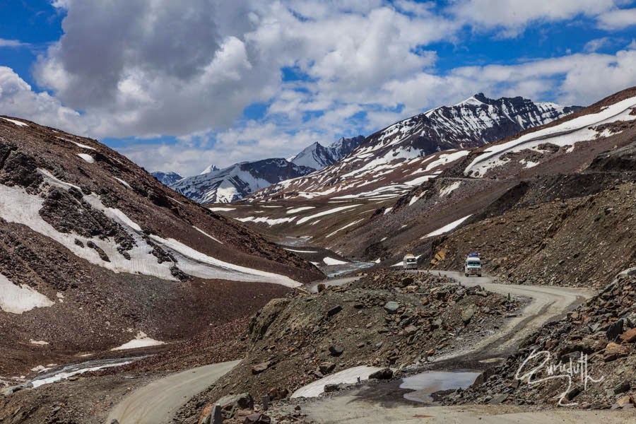
Series of panoramic pictures en-route to Pang |
For the night we too stayed at Pang, at one of the tents.
It was raining torrential all through the night and we got worried that next
day the road to Leh may get blocked due to landslides or flooding Nalas. But by
the morning we left Pang, it had stopped raining and to our luck the road to Leh
was open.
Fantastic,awesome landscape,Baba ji carry on, as ,Michael Palin — 'Once the travel bug bites there is no known antidote, and I know that I shall be happily infected until the end of my life
ReplyDeleteAshok, thank you for the fantastic photos and your explanations of your trip! From Wayne and Ella
ReplyDeleteI am happy that you liked my this travel blog too
DeleteThank you veerji for appreciating my travel blog
ReplyDeleteGreat Blog and interesting pictures.
ReplyDeleteThank you Deepak for appreciating my Blog
DeleteExcellent photos Gurudutt Sir
ReplyDeleteThank you Manjunath for your positive and encouraging complements
DeleteAshok,
ReplyDeleteAfter a long time I am reading your posts one by one. Great shots by Guru and complimented by crisp and nice narrative by you. Heard about this trip from you and now the pleasure of reading and seeing photos. Thanks.
Rajesh Naik.
Awesome, this is fresh breath. keep on carrying!
ReplyDeleteGood Pics for Kashmir products you can visit www.gudindia.com
ReplyDeleteRTT- Is A Reputable Travel Company Located In Srinagar Kashmir. With Rizz Tour And Travels.
ReplyDeleteLadakh tour packages
Vaishnodevi tours
Kashmir travel agency
Thank you for taking the chance to talk about this, I'm strongly about this and really like having to learn more about this type of field. Do you mind updating your site article with extra insight? It ought to be really beneficial for every one of us.
ReplyDeleteHow To Get Free Robux
Krishna flute Ringtone Download
ReplyDeletelike all the shayari are given here. Tana Status
ReplyDeleteTANA SHAYARI
New Tones of Mp3 Mobile and IOS Devices -
ReplyDeleteDownload Ringtones
All New Mp3 Ringtones
Ringtones
Ringtone Download
Premium Ringtone Download
Baralacha La Pass is renowned for its scenic beauty and serves as an important route for travelers and adventurers.
ReplyDeletehimachal tour package
Wow, This looks so beautiful! The mountains and quiet views are perfect for a peaceful trip. If anyone wants to visit, check out our Himachal Tour Packages
ReplyDeletefor a nice and budget-friendly journey!